Posts

Radio Navigational Warnings - Hydrographic Institute of the Republic of Croatia

Image
 GeoAdriatic Implementation of new technologies has not only simplified the visualisation of spatial data but has also made it necessary.  Hydrographic Institute of the Republic of Croatia (HHI) has created a geoportal GeoAdriatic to share with the public its specific spatial data used for producing up-to-date navigational charts and publications.  The HHI Nautical Department is National Coordinator for Navigational Warnings, as part of Maritime Safety Information (MSI), and publishes navigational warnings on the HHI website. Besides providing textual presentation of radio navigational warnings, Geoportal also enables a spatial view.  The data are collected, analysed, and published on working days from 7:30 a.m. to 3:30 p.m. S-124 Standard In the light of S-124 Standard, HHI has assumed a new structure of radio navigational warning information, and adapted it for update and display through GIS applications. Opensource QGIS The data are entered and updated through Opensource QGIS applic

PROMULGATION OF NAVIGATION AND METEOROLOGICAL WARNINGS IN THE REPUBLIC OF CROATIA

Image
NAVAL RADIO SERVICE According to the Global Maritime Distress and Safety System (GMDSS), the eastern part of the Adriatic Sea belongs to the marine area A1, in which the Republic of Croatia is obliged to ensure VHF, VHF DSC and NAVTEX signal coverage. The Law on Plovput defines that the mentioned tasks are performed by Plovput on behalf of the Republic of Croatia. ACTIVITIES OF THE MARINE RADIO SERVICE OF COASTAL RADIO STATIONS (ORP) The fundamental activities of the maritime radio service are as follows: • Constant vigilance on frequencies for danger; • Mediation in communication during distress, emergency and safety interventions coordinated by the National Search and Rescue Center (MRCC) in Rijeka, in accordance with the National Plan for Search and Rescue of Human Lives at Sea; • Mediation in communication when seeking medical advice from vessels; • Broadcasting of Maritime Safety Information (MSI) via VHF system and Navtex system; • Commercial radio service with sh

Navigation safety facilities and lighthouse service in the Republic of Croatia

Image
The Croatian partner in the MED OSMoSIS project, the company Plovput d.o.o. Split is 100% owned by the Republic of Croatia. The main activity of Plovput is in accordance with the Law on Plovput (Official Gazette No. 73/97) and Article 50/paragraph 3. of the Maritime Code (N.N. no. 181/04, 76/07, 146/08, 61/11, 56/13 and 26/15) defined as an activity of public interest for the Republic of Croatia (RC) which is implemented as a public authority through the following navigation safety services: arrangement and maintenance of maritime waterways, installation and maintenance of navigation safety facilities in internal sea waters and the territorial sea of the RC, radio service of the coastal radio stations by monitoring the frequencies of danger and safety on the maritime waterways of the Republic of Croatia (VHFDSC CH70 and VHF CH16), for the protection of human life and property at sea, removal of wrecks and sunken things in accordance with the provisions of special maritime regulations.

High resolution Atlas of Surface Currents in South European seas

Image
Sea surface currents are probably one of the most relevant variable for a variety of challenges concerning the the marine environment management (e.g. safe and  efficient navigation, pollution dispersion, ecological connectivity, ...) . Within the framework of the MED OSMoSIS and COSMO projects, the ICM-CSIC has developed an atlas of surface and subsurface (depth ~ 15 m) currents for the Southern European seas: the Mediterranean basin and the Canary-Iberian-Biscay waters (Martinez et al., 2022). Surface Climatological Currents for May The Atlas is based on today’s state of the art reanalyses of the ocean circulation provided by the Copernicus Marine Environment Monitoring Service (CMEMS). Climatological values are computed from the median of the empirical probability density functions. The Atlas also includes the variance matrix as well as a bimodality index providing further quantitative information about temporal variability of the current at each location. Rose of currents and varia

PING S-124 Navigational Warnings API - MED OSMoSIS Pilot Study

Image
  Shom is currently developing a platform dedicated to Nautical information named PING. The API (Application Programming Interface) Navigational Warnings S-124 module, developed within the MED OSMoSIS project, is the first increment of this platform and consists of the production and dissemination of Navigation Warnings (NW) through web services. Testing is being carried out on several aspects: the portal tools for NW production on the one hand, and the dissemination of navigational warnings for integration into client systems such as surveillance systems trough 2 protocols: WFS (Web Feature Services) and REST (Representational State Transfer). The different steps of the testing involve: -  the development of the API S-124 module itself, the installation of the hosting platform at Shom; -  the grant of access to the PING platform to participants from EU Member States; -  the issuing of navigational warnings by the French maritime authority through the portal tools;   -  the integrat

MED OSMoSIS CISE Pilot Study

Image
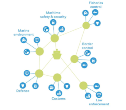
In the framework of the project, Shom is conducting a pilot study on CISE to assess the technical and financial needs for the integration of Shom’s data in the CISE network. The common information sharing environment (CISE) is an EU initiative providing a decentralized framework for point-to-point information exchange across sectors and borders. It is involving more than 300 EU and national authorities with responsibilities in maritime surveillance. CISE aims to make European and national maritime surveillance systems interoperable, enabling all concerned authorities to exchange information in an automatic and secure way. Carrying out many different operational surveillance tasks, national authorities directly benefit from being connected to CISE, in various sectors: In the context of the study, Shom is getting involved in the CISE Network by connecting its legacy system (data.shom.fr portal) to the French Node as data provider. This task is performed in cooperation with SGMer (French

Development of a Web GIS portal base platform

The Lead Partner of MED OSMoSIS - GMMA ( Special Service of EU Structural Funds for the Ministry of Maritime Affairs and Insular Policy ) is developing a Web GIS portal base platform (maritime surveillance) in which several modules and tasks are being analyzed. Among other facilities of the platform, such as the integration and the access of geo-information, applications and reports, it is planned to unify into one source all the available systems that provide AIS information. To accomplish this a systematic method of logistics is being directly developed at this time, that will incorporate all available AIS signal transmits at a national level and from different databases into the Web GIS portal, as a unique reliable reference. That means that more than 6 available sources will be incorporated into one. The same challenge may have been experienced in your country. If so, let us know at what degree, and if you have evolved a similar solution of transformation (eg. integration of meteor